Description:

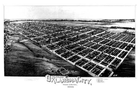
Panoramic views of American cities were very popular in the second half of the Nineteenth Century. Itinerant artists would travel to small- and medium-sized towns and draw these multi-dimensional maps which depicted the buildings, topography and infrastructure of the town. Although the points-of-view for these birdseye views appear to be ones of significant elevation, the sketches were actually made as the artist systematically wandered the town and sketched the buildings individually and then incorporated each into the larger drawing. The artist would then have the works printed as lithographs and sell them around town; they were often used in promotional literature by the towns’ chambers of commerce.
The view of Oklahoma City depicted here was done on February 22, 1890, ten months after the Land Run, by T. M. Fowler. Thaddeus Mortimer Fowler was born in Lowell, Massachusetts, on December 21, 1842, was wounded in the Civil War and ended up becoming a photographer. By the late 1870’s he had begun producing panoramic maps in the upper midwest and Pennsylvania. By the end of his 54 year career of making panoramic maps, Fowler had drawn 411 maps of cities in 21 states and Canada. He died in 1922.
Fowler’s view of our city shows just how densely populated it had become in such a short time. One item of special note is the inclusion of the Grand Canal which doesn’t appear on many maps or views of the city. The canal, Oklahoma City’s first major civic project was an attempt to bring water power into to the city, but it was quickly proven to be a civic folly because the North Canadian River simply did not supply enough consistent water to operate any mills. One can also see that the aptly named Reno Avenue really did lead travelers west out of the city to Fort Reno.
FURTHER READING
- Freeman, Larry. Historical Prints of American Cities. Watkins Glen, N.Y.: Century House, 1952.
- Library of Congress American Memory Project: Panoramic Maps: 1847-1929 http://memory.loc.gov/ammem/pmhtml/panhome.html
- Reps, John W. Bird's Eye Views: Historic Lithographs of North American Cities. Princeton, N. J.: Princeton Architectural Press, 1998.
- Warren, James R., Sr. "Thaddeus Mortimer Fowler, Bird's-eye View Artist." Special Libraries Association, Geography and Map Division Bulletin, No. 120, June 1980, pp. 27-35.
- Wise, Donald A. "Bird's-eye Views of Oklahoma towns" in The Chronicles of Oklahoma, vol. 67, no. 3 (Fall 1989): 228- 247. 4 June 1998